Images by Jim Harris
On the windward side of a knife-edge ridge, the remnants of a massive cornice clings above a rocky abyss. The thin line of snow stretches toward the horizon. Delicately, I pick a route toward the summit of 10,308-foot Sheepherder Peak, taking advantage of firm spring snow while avoiding triggering its collapse.
Jim Harris and I are 70 miles into an ambitious 120-mile ski traverse. We started five days earlier at the base of Sylvan Pass near Cody, Wyoming. From there, rarely descending below timberline, Jim and I travel more than 40 miles to Cooke City, Montana. During those first few days we rarely descend below timberline. From this high, long ridge panoramic views of the greater Yellowstone inspire us during many long miles.
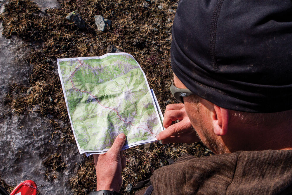
Forrest plots their location along the intended route that follows the border of Yellowstone National Park and the North Abaroka Wilderness
The nearly vertical rock flanks of Grand Teton to the south and Pilot Peak to the east contrast against a universe of blue sky, lush green valleys and snow-covered summits. Like lighthouses in the days of old, these massive rock spires are familiar and reassuring landmarks. To the west, Old Faithful emits a visible burst of steam.
“On the east side of the Yellowstone the eye takes in at a glance one of the most symmetrical and remarkable ranges of mountains I have ever seen in the West.” Wrote Ferdinand Hayden about the Absaroka during his historic 1871 geological survey of the Yellowstone region. “Several of my party who had visited Europe regarded this range as in no way inferior in beauty to any in that far-famed country.”
The majestic Absaroka Range is the largest in the Yellowstone region, and arguably the wildest. Four separate Wilderness areas comprising more than 2.5 million acres, combined with adjacent Yellowstone National Park, protect the primeval character of this rugged country and ensure that future generations have opportunities for exploration, adventure and discovery. On this spring tour, we are that future generation.
In the ancient tradition of hunters, soldiers and other winter travelers of Northern Europe and Central Asia, we fasten long boards to our feet in an effort to navigate frozen mountainous terrain.
In the nineteenth century Norwegian settlers introduced skiing to North America. On the snow-covered mountains of the western frontier, hardy Scandinavians found great utility in their ancient skiing tradition. Perhaps most famous of these immigrants is John “Snowshoe” Thompson. For twenty winters starting in 1856, Thompson carried mail and supplies over the snowy Sierra from Placerville, California to Genoa and Virginia City, Nevada; a three-day journey on 10-foot homemade skis.
“He flew down the mountainside. He did not ride astride his pole or drag it to one side as was the practice of other snow-shoers, but held it horizontally before him after the manner of a tightrope walker.” Dan de Quille wrote in the Virigina City Territorial Enterprise. “His appearance was graceful, swaying his balance pole to one side and the other in the manner that a soaring eagle dips its wings.”
This “Viking of the Sierra” later went on to teach others how to make and use skis.
Early in the 20th century, mountaineers in the Sierras, Cascades, and Rocky Mountains embraced the Norwegian ski tradition and became the first to explore the West’s great expanses of snow-covered highlands. This new generation of ski-mountaineers included David Brower who wrote in the Manual of Ski Mountaineering:

Forrest ascends a snow-covered ridge above Sunlight Basin
“Not too subtly, then, I was trying to expose my delegates to the new generation to the good things that could happen if they were to turn their skis to the wilderness for a few winter week ends at least. They would have new frontiers to explore every time there is a new fall of snow. They would find country – especially the Western uplands – measured in millions of acres where skis have never penetrated. They would learn that there is need for all their new skill in inventing ways to achieve more mobility and safety with less weight. In the course of all this, they would also find out that in winter one of the finest methods of transportation ever invented is a man’s own two feet – plus seven-foot skis.”
First published in 1942, to prepare the legendary 10th Mountain Division for winter combat in the mountains of Europe, Brower’s seminal book went through multiple revisions and was last printed in 1969. Following World War II, Brower became the Executive Director of the Sierra Club and played a leading role in the passage of the 1964 Wilderness Act that laid the framework for protecting the primordial mountain wilderness of the Absaroka Range.
Following in the ski tracks of Thompson and Brower, in January of 1961 Rod Newcomb and Frank Ewing became the first to ski across the crest of the Absaroka Range. Starting in Jackson Hole the men skied 70 miles to Cody, Wyoming. Newcomb would later become a pioneer of snow science and avalanche education and mentor yet another generation (including myself) on how to safely travel through the West’s winter landscapes. In 2004, he was the recipient of Honorary Membership by the American Avalanche Association, the highest honor given to avalanche researchers and practitioners.
In the northern reaches of the Absaroka Range, our route follows the divide between the Yellowstone, Shoshone, and Clarks Fork rivers. Over eons, stream and glacial erosion have sculpted a massive volcanic plateau. Extending for 150 miles across the Montana-Wyoming border, the volcanic debris has been carved into jagged peaks, high cirques and steep rocky slopes.
Below, deep valleys, thick forests and alpine meadows provide refuge for grizzly, wolf, mountain lion and wolverine. Large clawed carnivore tracks are visible in the snow and mud.
In the last 20 years, I’ve completed high traverses of all the major mountain ranges in the Greater Yellowstone including the Teton, Wind River, Gros Ventre, Madison, Gallatin and Beartooth ranges. Yet the Absaroka Range, containing some of the region’s most complex and imposing terrain, have remained elusive.
Few skiers venture deep into the Absaroka Range. Access is tough and beta scant. One who did was Bozeman resident Hans Saari. Alongside fellow ski-mountaineer Kris Erickson, Saari pioneered steep technical ski lines throughout the range’s northern reaches. Nearly 20 years later, many of those descents have yet to be repeated.
Guiding together in the Tetons for a few summers, Saari and I traded stories of ski explorations and dreams for future adventures. We both saw skiing as more than athletic challenge: It was also a means to travel, explore and discover wild places. “It’s a personal expression, an embodiment, either in the objective or in the actual movement, of what I like to think is my soul”, Hans posted in a dispatch from Antarctica in 2000.
In 2001, Saari was killed in the French Alps while attempting to ski a variation of Gervasutti Couloir on the east face of Mont Blanc. In his memory, The Hans Saari Fund was established to promote ski mountaineering by providing financial aid to adventurers exploring on skis. In 2012 it helped fund our Absaroka traverse.
Unlike Saari, my focus isn’t big vertical lines. Instead I’m interested in big horizontal lines through technical terrain. Both require an intimate relationship with landscape and climate. Pioneering big committing ski descents or high mountain traverses often involves years of research while waiting for favorable weather and ideal conditions when snow cover is both adequate and stable.
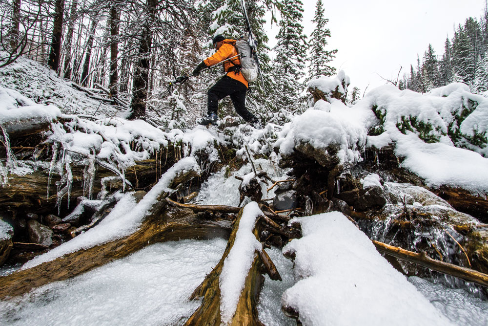
Covered in wet snow, slick rocks and fallen timber are nearly as treacherous as the avalanche prone slopes above.
With the exception of a maze of snowmobile tracks in the vicinity of Daisy Pass near Cooke City, Jim and I see no other signs of winter travelers. For the entire route we do our own route finding, breaking trail through diverse snow conditions that vary from spring crust, to deep unconsolidated facets, to wet fresh snow.
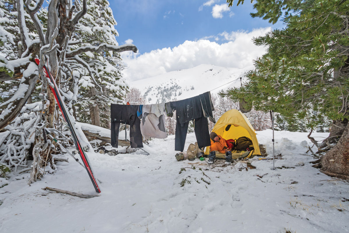
After a cool night in a high basin in the headwaters of the Boulder River a spring melt-freeze crust provides an ideal traveling surface. We rise early, before the sun’s first rays break the eastern horizon and sip on a hot brew of cowboy coffee. Cold fingers struggle to stuff sleeping bags into our packs and feet into stiff ski boots.
Following the natural contours of landscape we connect long ridgelines, high benches, and treeless cirques. For long stretches, lasting up to several miles, the terrain is gentle and we progress rapidly. The challenge involves linking up the easy reaches through careful route finding, climbing up and down exposed rock ridges, and skiing steep snowfields and couloirs.
Jim and I are surrounded by a seemingly infinite mountain expanse. Precipitous snow-filled couloirs, alpine cirques, and endless ridgelines stir our imaginations. I sense Jim’s desire to challenge himself on one of the steeper slopes.
Having carved turns high in Utah’s Wasatch, the European Alps, British Columbia and Alaska, Jim is a highly accomplished ski-mountaineer. Jim also enjoys long epic wilderness journeys like his 430-mile trek and rafting trip across Wrangell-St. Elias National Park and Preserve. This, however, is his first time applying his skiing skills on a long wilderness traverse.
We consider a side trip to ski several enticing couloirs on an unnamed nearby peak. Our dwindling food supply, however, is just enough to complete the traverse. We continue on.

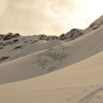
Traversing above a massive cornice high on the crest.
We have several route options. Below us, to the north, is mellower terrain below timberline. Sheltered from the wind and sun, a series of benches promise reliable snow cover and fewer obstacles. While longer, we’d be less likely to get cliffed out. Yet, we desire to stay in the alpine terrain along the crest. Our topo maps indicate a high, aesthetic route following the spine of the northern Absarokas for more than 50 miles.
North of Cooke City, we spent a day in the headwaters of Slough Creek battling through brush and deadfall. During the strenuous miles I questioned what we were doing and why we even brought skis. Regaining the grandeur of the snow covered high country, I knew.
Jim and I decide to take our chances on a higher route along the crest.
We advance along a series of ridges between Boulder and Hellroaring Creeks. Exposed to sun and prevailing winds, the southwestern slopes are nearly void of snow. Often the most efficient line is along the exact crest, where a winter’s worth of blowing snow was deposited on the windward side. Recent warm weather has caused some of these massive overhanging cornices to fail, however, and avalanche debris is scattered 1,000 feet below. We follow the remaining narrow band of snow for miles at a time.
Navigating around 10,727-foot Crow Mountain proves more challenging. After contouring to a high saddle on its western flank, an intimidating north face stops us. Jim eyes a precipitous snow covered ledge that winds between cliffs toward the top of the glacier. The only other viable way is to downclimb a lower angle section of the crumbling cliff band.
I opt to downclimb but soon regret it. The first 100 feet of my descent go smoothly, but 10 feet above the glacier the cliff steepens, and gaps between the rock and glacier hint of a hidden bergschrund. I feel trapped. Escaping via a sketchy traverse, I find a narrow, snowy gully that provides safe passage.
As I chop out a ledge where I can click into my skis, Jim confidently traverses the exposed snow ledge above, effortlessly pointing his skis down the steep fall line. Soon he is relaxing at a small lake at the foot of the glacier. When I catch him, he can’t stop grinning, thrilled with the descent and watching me flounder.
Jim Harris and I met in 2011 on a ski expedition to Antarctica. His friendly demeanor, competence on skis and passion for exploration impressed me, and during our flight back to the States we hatched an idea for a spring ski traverse.
That afternoon, the weather begins to deteriorate. Thick, dark clouds march across southwest Montana. As we traverse the headwaters of Meatrack Creek toward 10,730-foot Pyramid Peak, the rain begins. We stop and put up our small single wall tent on a bench near timberline. The rain continues.

The northern Absaroka Range forms the watershed divide between the Boulder and Yellowstone Rivers. In the late spring, skiing along its crest requires connecting lingering snowfields.
By the time we’ve retreated inside, we’re drenched. Inside, our silnylon shelter drips with condensation, and our light down sleeping bags become increasingly wet and lose their loft. The temperature drops and as I lie shivering rain turns to snow. By morning, six inches of heavy wet snow has accumulated outside.
“A light pack makes a trip more pleasant and control of skiing more certain,” advised Brower. Our strategy to travel our 120-mile route, including over 35,000 feet of climbing across the complex crest of the Absaroka Range in just eight days, is to go as light as possible.
Dramatic improvements in ski and camping equipment are enabling modern ski–mountaineers to travel lighter and faster through more technical terrain. Unlike the long wooden skis and heavy leather boots used by our predecessors, we don carbon fiber skis and plastic boots. Not counting food or fuel our packs weigh only 10 pounds each. Confidently we navigate the treacherous and exposed topography.
It’s springtime and the weather forecast predicted nighttime temperatures around freezing and no major storms. We have 40° down sleeping bags, a 3-season single wall tent, and while our minimalist approach allows agility and efficient travel we are ill-equipped for long spells of bad weather. Nor do we have enough extra food or fuel to wait out the weather for more than a day.
Wet, cold and lacking visibility we hole up for the day. The weather continues to deteriorate. All night, wet snowflakes collide with our tent.
By the next morning, the storm has deposited more than a foot of heavy snow. In addition to being cold, wet, and mildly hypothermic we’re becoming increasingly concerned about avalanches. Ten miles to the north, our planned route requires crossing the perfidious avalanche-prone slopes surrounding 11,212-foot Mount Cowen.
An afternoon thunderstorm the day before left us soaked before the temps dropped and rain turned to snow. After this sunny window, the storm resumed and dumped a foot on the 6″ that had already fallen. the resulting spike in avalanche hazard spurred us to end our traverse earlier than planned.
Seven days and 80 miles into our traverse, we bail. We stuff soggy gear into our packs and fight our way westward over the windy Absaroka crest. Alternatively, descending east down Meatrack Creek, to avoid crossing the weather deluged divide, would initially be easier, and yet would deposit us along the Boulder River, miles from nowhere.
Visibility is poor and previously barren ridges are now blanketed in thick wet snow. As we cautiously pick our way down the steep headwaters of Mill Creek, we trigger several small avalanches. Hidden rocks leave long gauges in the bases of our skis. Thick wet brush and fallen trees further impede our exit.
Lower down, we find final reprieve on an old logging road and hitch a ride in the back of a rusty pickup into Livingston. That night we feast on pizza, beer, and storytelling.
The day after our exit high pressure returns to southern Montana. As we head home through Yellowstone, fresh snow along the high crest of the Absaroka glistens below a cloudless blue sky. I lament our decision until I hear a radio report of an avalanche that buried and seriously injured a skier in the nearby Gallatin Range during the same storm.
My thoughts return to Brower, Newcomb and Saari, and I know they would agree we made the right decision.

[…] Jackson Hole adventurer Forrest McCarthy even have a home, or does it just seem like he is constantly moving from one bivvy to the next? Here […]
Thanks – great story.
What a great experience! Also a wonderful write up and photo’s